Weather phenomena captured around the world
From mesmerising clouds, to dizzying optical illusions; these are the weather phenomenon that have dazzled the globe.
May 3, 2023
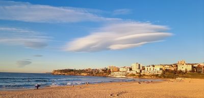
Beachgoers gracing Australia's most famous stretch of sand were treated to a rare, and strange, sight as a "saucer-shaped" cloud hovered above Bondi on Wednesday morning.
The images, shared by Weatherzone, show a solitary lenticular cloud.
"(It was) caused by mountain waves flowing off the Blue Mountains," the weather service says.
"Mountain waves, as the name suggests, are waves of rising and sinking air that are often caused when wind flows over a mountain range.
"Under certain conditions, small areas of cloud can form at the crests of each wave, on the leeward (downwind) side of the mountain range.
"This is what happened on Wednesday morning."

April 15, 2023
Northern light enthusiasts in Alaska got a surprise on Saturday when a light baby blue spiral resembling a galaxy appeared amid the aurora.
However the cause was a little more mundane than an alien invasion or portal.
The spiral formed from excess fuel released from a SpaceX rocket launched from California about three hours before.
"When they do that at high altitudes, that fuel turns into ice," space physicist Don Hampton, a research associate professor at the University of Alaska Fairbanks Geophysical Institute, said.
"If it happens to be in the sunlight, when you're in the darkness on the ground, you can see it as a sort of big cloud, and sometimes it's swirly."
It's not a common sight, with Hampton saying he's only seen it about three times.
- with Associated Press
January 8, 2023
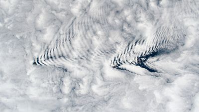
Strange arrow shaped-cloud formations were photographed above the Crozet Islands, which are located halfway between South Africa and Antarctica, in January.
The phenomenon are called wave clouds and it's not the first time they've formed, NASA explained.
"Wave cloud formations over these islands are a result of stable air masses over the South Indian Ocean flowing over and around the mountainous island terrain," it said.
"Wave clouds are produced when the warm air on the leeward side is pushed back upwards.
"The rising movement causes the moisture in the air to recondense and form more clouds, before it is forced back downward by gravity and evaporates again. The cycle repeats and forms a ripple pattern."
March 19, 2023
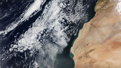
A distinct cloud formation has also been photographed above the Canary Islands.
They are called Von Kármán vortices.
NASA explained "they act like fingerprints for the movement of air."
"They can occur whenever an object interrupts airflow. In this case, they occurred as winds rushed past the tall volcanic peaks of the Canary Islands," the space agency said.
"Cloud vortices are often spotted downwind of isolated islands including near Guadalupe Island, near the coast of Chile, and in the Indian Ocean".
January 25, 2023
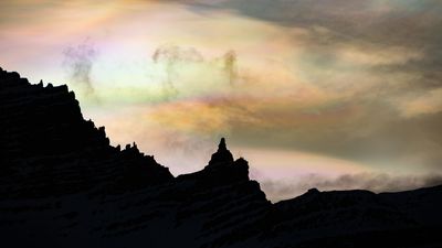
When sunset fell last week, nurse Jónína Guðrún Óskarsdóttir headed out into the brisk dusk near her home in eastern Iceland in the hopes of capturing the northern lights.
What she managed to photograph was much rarer.

As the sun slipped below the horizon the clouds shimmered and appeared as if they were painted in multiple colours.
These special clouds are known as polar stratospheric clouds (PSC).
And they can only form under special conditions.

They develop when the second layer of the atmosphere, the stratosphere, reaches temperatures below -81C.
Normally clouds don't form here, but when it's cold enough tiny ice crystals are born, allowing them to.

Óskarsdóttir has witnessed PSC before so she knew immediately what it was.
"Those clouds can't be mistaken for something else," she told 9news.com.au.
"They are very bright and are not moving while other clouds can be moving fast.
"They appear in the sky and stay there sometimes for hours and you can see the colours, sometimes pale and sometimes bright.
"It's hard to explain you just accept the glory of nature and enjoy"
January 19, 2023
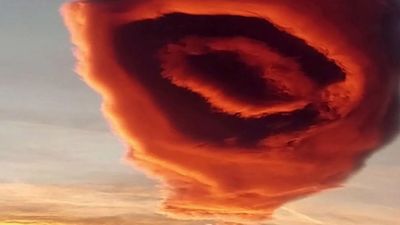
A bizarre UFO-shaped cloud over a Turkish city left onlookers baffled and went viral on social media.
The giant rose-coloured cloud appeared over Bursa in the country's north west last Thursday January 19, the Reuters news agency reports.
Meteorologists identified the weather phenomenon as a lenticular, or lens, cloud.
They are usually found at height of 2000m to 5000m.The colours of the cloud changed as it moved around the sun.
January 27, 2022
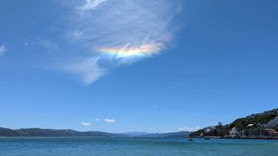
Days after Christmas, a rare circumhorizontal arc formed over Wellington, on New Zealand's North Island.
The rare sight occurs when ice crystals develop high in the sky.
A halo forms when sunlight enters the horizontally-oriented crystals.
They can only be seen when the light source, either the sun or moon, sits at more than 58 degrees.
Luckily this circumhorizontal arc was immortalised by some eagle-eyed residents.

Karaka Bay resident Nick Tyler happened to look up at the right moment to see the short-lived "cloud-bow" formation.

And Stephanie Turgoose was enjoying a cup of tea on her friend's balcony in Karaka Bay when she noticed the "horizontal rainbow".
She snapped a quick photo so it could live on in memory.
April 6, 2021
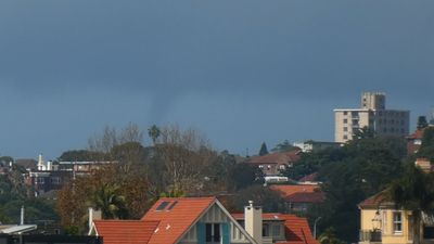
As rain and thunderstorms loomed for Sydney, a rare water spout was spotted spinning off Bondi, Australia's most famous beach.

A waterspout is a rotating column of water that contains an intense vortex similar to that of a tornado.
Waterspouts usually occur over warm tropical ocean waters and appears as a funnel-shaped cloud descending from the sky.